NOAA Ocean Exploration 2023 U.S. West Coast Expeditions Overview (EX2208, EX2301, EX2308, EX2309)
From October 2022 through December 2023, NOAA Ocean Exploration and partners will conduct a series of telepresence-enabled ocean exploration expeditions on NOAA Ship Okeanos Explorer to improve knowledge about unexplored and poorly understood deepwater areas of the U.S. West Coast from Southern California to Washington. Data collected will establish a baseline in these areas to catalyze further exploration, research, and management activities.
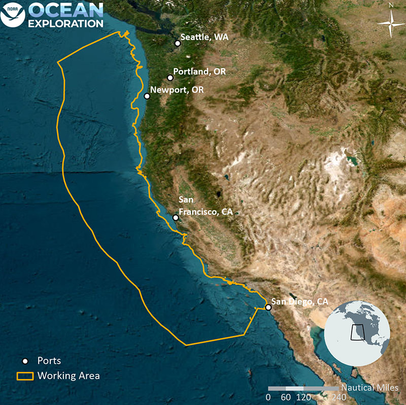
Anticipated extent of the operating area for the West Coast expeditions (EX2208, EX2301, EX2308, and EX2309). These expeditions will provide high-resolution information about seafloor features and associated marine habitats and an opportunity for scientists, students, and managers to engage in exploration of largely unknown areas in real time. Map courtesy of NOAA Ocean Exploration. Download largest version (jpg, 1.5 MB).
Geologically, the deep waters off the West Coast feature a convergent plate boundary, submarine volcanism, and hydrothermal vents. Biologically, they contain a variety of marine life supported by an abundance of hard substrate as well as hydrothermal vents. In addition, these waters provide a known migration corridor for species such as tuna, sharks, and whales. Because of its active geological features, rich biodiversity, and proximity to the coastline, scientists have been studying these deep waters for decades. Nevertheless, there is still much to be learned about the deep-ocean environment in this region and its geological and biological systems and how they influence each other.
As we increasingly look to the deep ocean for the resources it holds and the services it can provide, more data are needed so we can sustainably manage and protect it. There’s a lot of ocean to explore, but exploration in one area can help us better understand similar habitats in other areas and the biodiversity and ecological processes that these habitats support. Exploration also contributes to our understanding of the geological history and processes, including geohazards, of the planet as a whole.
The West Coast series of expeditions will contribute to EXpanding Pacific Research and Exploration of Submerged Systems (EXPRESS), a multiyear, multipartner cooperative research campaign in deepwater areas of California, Oregon, and Washington, including the continental shelf and slope. Data and information collected during the EXPRESS campaign are intended to guide wise use of living marine resources and habitats, inform ocean energy and mineral resource decisions, and improve offshore hazard assessments. EXPRESS builds on the momentum of past U.S. campaigns and international initiatives to support ecosystem-based management of marine resources and technologies and also provides an opportunity to highlight the uniqueness and importance of deepwater environments.
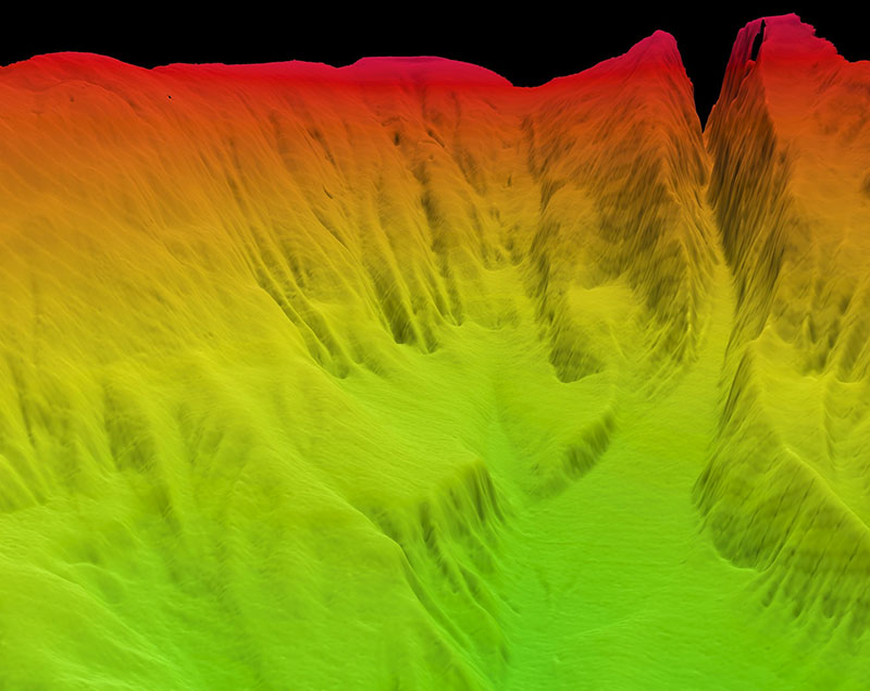
Map of Santa Cruz Canyon off the coast of California produced using data collected during the NOAA Ship Okeanos Explorer California Shakedown Cruise 2011. Image courtesy of NOAA Ocean Exploration, California Shakedown Cruise 2011: Exploring California's National Marine Sanctuaries. Download largest version (jpg, 1.3 MB).
Collectively, these expeditions will use Okeanos Explorer’s deepwater acoustic systems (Kongsberg EM 304 multibeam sonar, Simrad EK60 and EK80 split-beam fisheries sonars, Knudsen 3260 chirp sub-bottom profiler sonar, and Teledyne acoustic Doppler current profiler), NOAA Ocean Exploration’s dual-bodied deepwater remotely operated vehicle (ROV) system Seirios and Deep Discoverer, the University of Southern Mississippi’s autonomous underwater vehicles (AUVs) Eagle Ray and Mola Mola, and a high-bandwidth satellite connection for real-time ship-to-shore communications. Conductivity, temperature, and depth (CTD) rosette operations are also expected.
The ROVs will be used for high-resolution visual surveys of water column and seafloor habitats as well as biological and geological sampling. The AUVs will be used to collect high-resolution mapping data and to conduct visual surveys.
Planned Expeditions
NOAA and partners conducted an expedition in support of EXPRESS (EX2208) in October 2022 and will conduct four additional telepresence-enabled expeditions along the U.S. West Coast in support of the campaign during 2023. Live video and data from ROV dives and multibeam sonar mapping operations will be shared in real time with shore-based participants and the public. Expedition numbers, ports of call, and operational modes for the remaining expeditions are as follows:
- EX2301: April 2023, Portland, Oregon to Seattle, Washington – EXPRESS: Shakedown and West Coast Exploration (ROV and Mapping)
- EX2308: October 2023, San Francisco, California to San Francisco, California – EXPRESS: Exploration of Central California Coast (AUV and Mapping)
- EX2309: November 2023, San Francisco, California to San Francisco, California – EXPRESS: West Coast Exploration (ROV)
In addition to improving fundamental understanding of the region, mapping data collected during these expeditions will inform ROV dive planning. ROV dives from 250 to 6,000 meters in depth are expected to explore deep-sea coral and sponge habitats, potential hydrothermal vent and fracture zones (and related geohazards), and the water column.
NOAA will incorporate the results of the 2021 and 2022 calls for input and priorities from resource managers to establish expedition objectives and refine operating areas. In the months leading up to the ROV expeditions, collaborative dive planning calls will be held to discuss specific dive targets.
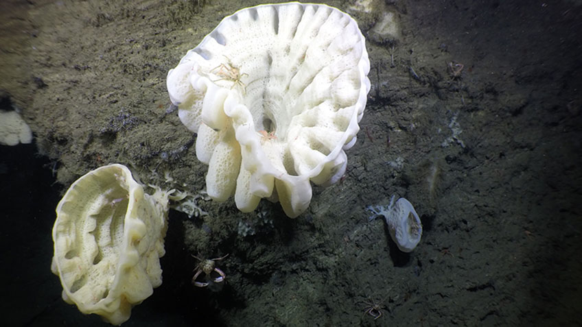
Heterochone sp. glass sponges seen growing on a vertical rock face with shrimp and crab associates in the Cordell Bank National Marine Sanctuary off California during the Surveying Deep-Sea Corals, Sponges, and Fish Habitat expedition in 2019. Image courtesy of NOAA Ocean Exploration, Surveying Deep-sea Corals, Sponges, and Fish Habitat. Download largest version (jpg, 1.8 MB).
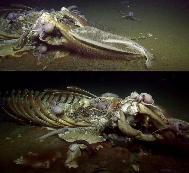
Whale fall explored during a 2019 expedition on Exploration Vessel Nautilus in the Monterey Bay National Marine Sanctuary off California. Image courtesy of Ocean Exploration Trust/NOAA. Download largest version (jpg, 1.1 MB).
Goals
NOAA priorities for the deep waters of the U.S. West Coast combine science, education, outreach, and open data to provide a better understanding of this important marine region. Specific goals include:
- Improve knowledge of unexplored deepwater areas along the U.S. West Coast to inform management needs for sensitive habitats, geological features, and potential resources.
- Locate and characterize deep-sea coral, sponge, and hydrothermal communities.
- Collect high-resolution bathymetry in areas with no or low-quality sonar data to extend bathymetric mapping coverage in support of the National Strategy for Mapping, Exploring, and Characterizing the United States Exclusive Economic Zone and Seabed 2030.
- Ground truth existing bathymetric data, habitat suitability models, seafloor composition models, and inferred vent sites.
- Characterize water column habitats using acoustics, visual observations, and emerging technologies.
- Collect data to enhance predictive capabilities for vulnerable marine habitats, seafloor composition, seamount formation, plate tectonics, hydrothermal vents, critical minerals, and submarine geohazards.
- Investigate biogeographic patterns of deep-sea ecosystems and connectivity for use in broader comparisons of deepwater habitats throughout the Pacific basin.
- Map, survey, and sample geological features, including convergent plate boundaries, hydrothermal vents, extinct polymetallic sulfide systems, and fracture and fault zones to better understand the geological context of the region and improve knowledge of past and potential future geohazards (e.g., large magnitude, repeating earthquakes along the West Coast).
- Engage a broad spectrum of the scientific community and public in telepresence-based exploration and provide publicly accessible data and information products to spur further exploration, research, and management activities.
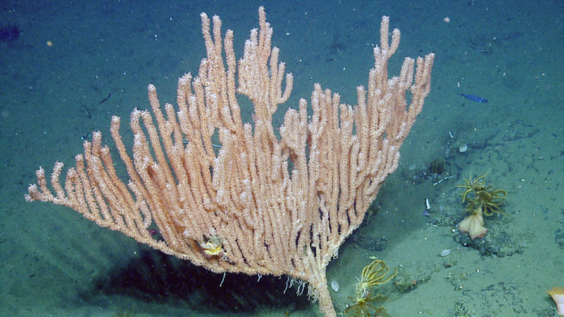
Bamboo coral seen off the Oregon coast during a 2016 expedition on Exploration Vessel Nautilus. Image courtesy of Ocean Exploration Trust/NOAA. Download largest version (jpg, 420 KB).
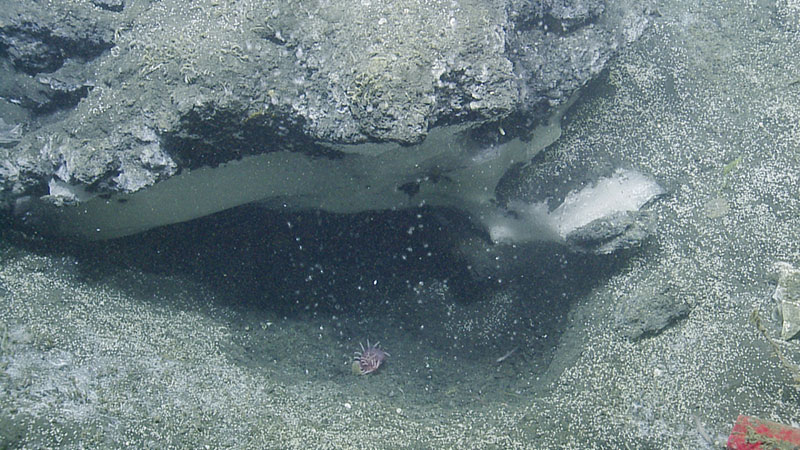
A methane seep with two forms of methane — gas (bubbles) and solid (hydrate, methane frozen in water) seen in Astoria Canyon off the Oregon coast during a 2016 expedition on Exploration Vessel Nautilus. Image courtesy of Ocean Exploration Trust/NOAA. Download largest version (jpg, 1.1 MB).
How to Get Involved
NOAA Ocean Exploration is currently building a core team of scientists to actively participate in the U.S. West Coast expeditions. These scientists will work from shore as full members of the science team. Shoreside team members participate in the expedition by standing watch during ROV dives, reviewing the latest data coming off the ship, and providing input into a standard suite of products and the day-to-day operations of the ship. This core team is expected to 1) represent the broad interests of the marine science community, 2) contribute to real-time annotation and data logging, and 3) help identify and engage additional shore-based explorers to contribute to the mission. This team will be complemented by these other shoreside scientists, including those with dive-specific expertise.
If you are interested in discussing specific details or have questions about the West Coast series of expeditions, please contact:
Thomas Morrow
Expedition Manager
EX2208, EX2301, EX2309 Expedition Coordinator
thomas.morrow@noaa.gov
Sam Candio
EX2301 Expedition Coordinator
samuel.candio@noaa.gov
Sam Cuellar
EX2308 Expedition Coordinator
samuel.cuellar@noaa.gov
Published February 22, 2023